FOLLOW US
LinkedIn
Instagram
YouTube
GitHub
MENU


SOLUTION
Smart City · Public Transport
Integrated dispatching, analytics, and onboard platform that has delivered +$115M/year in additional revenue for public transport networks. Deploy in 3–6 months
SMART CITY IS FOR
Built for the people who run cities
Transport authorities
Low fare collection, no visibility into where revenue leaks, no single control point for the network
› Real-time audit dashboard + 30% revenue uplift
› Real-time audit dashboard + 30% revenue uplift
Public transport operators
Excess fleet, inefficient schedules, high operational cost and poor on-time performance
› 15–25% fleet cost reduction in 6 months
› 15–25% fleet cost reduction in 6 months
Smart city programs
Fragmented vendors, no unified data layer, slow procurement cycle
› End-to-end stack, single contract
› End-to-end stack, single contract
Public transport demo
Vehicles, routes, and real-time traffic
Most cities don't have a data problem. They have a visibility problem. Smart City system follows public transport in real time: traffic conditions, vehicle speed and moving in real time. Insurance for passengers and transparency for the public transport system


THE PROBLEM
Public transport is losing money every day
LEAK 1: Fare evasion
It is happening all the time, and you need to know which routes, which shifts, which districts. Smart city maps it and sends inspectors exactly where it's highest
LEAK 2: Outdated scheduling
Vehicles are dispatched based on legacy timetables. Smart city reroutes using live demand — cutting excess fleet use by 15–25%
LEAK 3: OUTDATED ROUTES
Origin-destination data shows exactly which routes are underperforming. After identifying them, the Smart city team models the fix, and helps you deploy it
LEAK 4: SLOW BUSES
With cities’ constant growth, some buses get into traffic jams, slowing to 10–15 km/h on key corridors. Do the network speed analysis with the Smart City team and plan targeted interventions — dedicated lanes, junction fixes
Cities using our platform grow fare
revenue by up to 30%
+$115M
Additional fare revenue/year
$15B+
Revenue processed in 2025
+30%
Increase in fare collection
15–25%
Fleet cost reduction
6-9 months
To production rollout
100M+
Users on Yango infrastructure
REAL-TIME TRAFFIC FOR ALL

THE PLATFORM
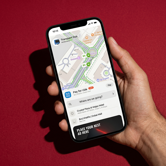
Passenger app


Real-time route planning and multi-modal journeys, live from day one of deployment
COST-EFFECTIVE PUBLIC TRANSPORT
Route & schedule management


Planners edit stops, intervals, and variants directly on the map
REAL-TIME OPERATIONS
Movement & speed analytics
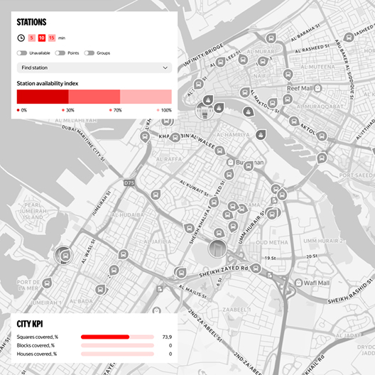

Corridor-level speed heatmap with KPIs: avg speed, slowdown, delay per km
SCHEDULE OPTIMIZATION
Live fleet & schedule view

Dispatchers see every vehicle in real time against a planned schedule
FLEET ROUTE PLANNING
Network route layer


Full bus network with stop-level load data, underserved areas surface immediately
ROUTE NETWORK OPTIMIZATION
Inspector routing


Targets generated daily from live fare payment-to-passenger ratios
PAYMENT REGULATION
CONTROL REVENUE

CASES
Increased revenue by $115M
The city network suffered from inefficient route planning, undetected fare evasion, and excess fleet deployment. We deployed integrated analytics, real-time dispatching, and onboard equipment. Inspector routes were optimized using live payment-to-passenger ratios. Vehicle classes and service intervals were redesigned based on actual origin–destination demand
Bus speed bottleneck solved
Network speed analysis identified specific corridors where low operating speeds caused unreliable service. Data-driven recommendations — dedicated bus lanes, junction reorganization — were targeted precisely at those bottlenecks. The speed map became the city's core diagnostic tool for corridor-level investment decisions
Demand matches smart data
+30%
Fare revenue increase
25%
Fleet cost reduction
+$115M
Additional revenue / year
3 months
To Phase 1 live
Smart Network Management
Smart City platform integrates passenger flow and payment data into a single dashboard for real-time fleet control and automated capacity optimization. Dispatchers monitor live vehicle conditions while inspectors receive daily, AI-generated routes targeting areas with the highest fare evasion. To eliminate revenue loss, the system uses origin-destination matrices to redesign underperforming schedules into demand-matched intervals. Every operation relies on precise sensor data and localized deployment, ensuring the city maintains full data sovereignty
TIMELINE

WHY TRUST US
PUBLIC TRANSPORT TO SMART CITY
Not a startup. Not a consultancy. A proven platform running mobility with a tech partner
100M+
Active users on Yango infrastructure
End-to-end
Software + hardware + support — single contract, one vendor
$15B+
Revenue processed through platform in 2024
3–6 mo
Typical time from contract to Phase 1 production
Performance
Commercial model tied to your results — not license fees
Sovereign
Localized control, data residency, operational independence
TALK TO A HUMAN
URBAN TRANSPORT ADVISORY
A consultation is done with our city mobility architects, who are former transport planners and data engineers who have worked with municipal authorities across 15+ countries. They don't demo the product — they help you understand whether it fits your network, estimate your revenue uplift potential, and map out the rollout path
EXPERTISE
Route network redesign • Revenue recovery • Fleet optimization • Government procurement • Smart city integration • Fare system analytics
NEED A UNIQUE SOLUTION?
DISCOVER,
BUILD, RUN
EMAIL US
info@yango-b2b.com
PRODUCTS & PLATFORMS
EMAIL US


© 2026 Yango Tech. All rights reserved.
Yango Tech, Offices 5, One Central, 6th Floor, Dubai
Cookies Policy